On this page
- What Zone AE describes
- What Zone X describes
- The annual chance is not a calendar promise
- Locate the building rather than only the parcel
- Effective and preliminary maps have different roles
- Ask about amendments and supporting documents
- Insurance requirements and insurance decisions differ
- Homeowners insurance is a separate review
- A hypothetical comparison between two listings
- Bring useful questions to the showing and inspection
- Build a simple map review checklist
- Use the designation to ask better questions
- Sources and reference material
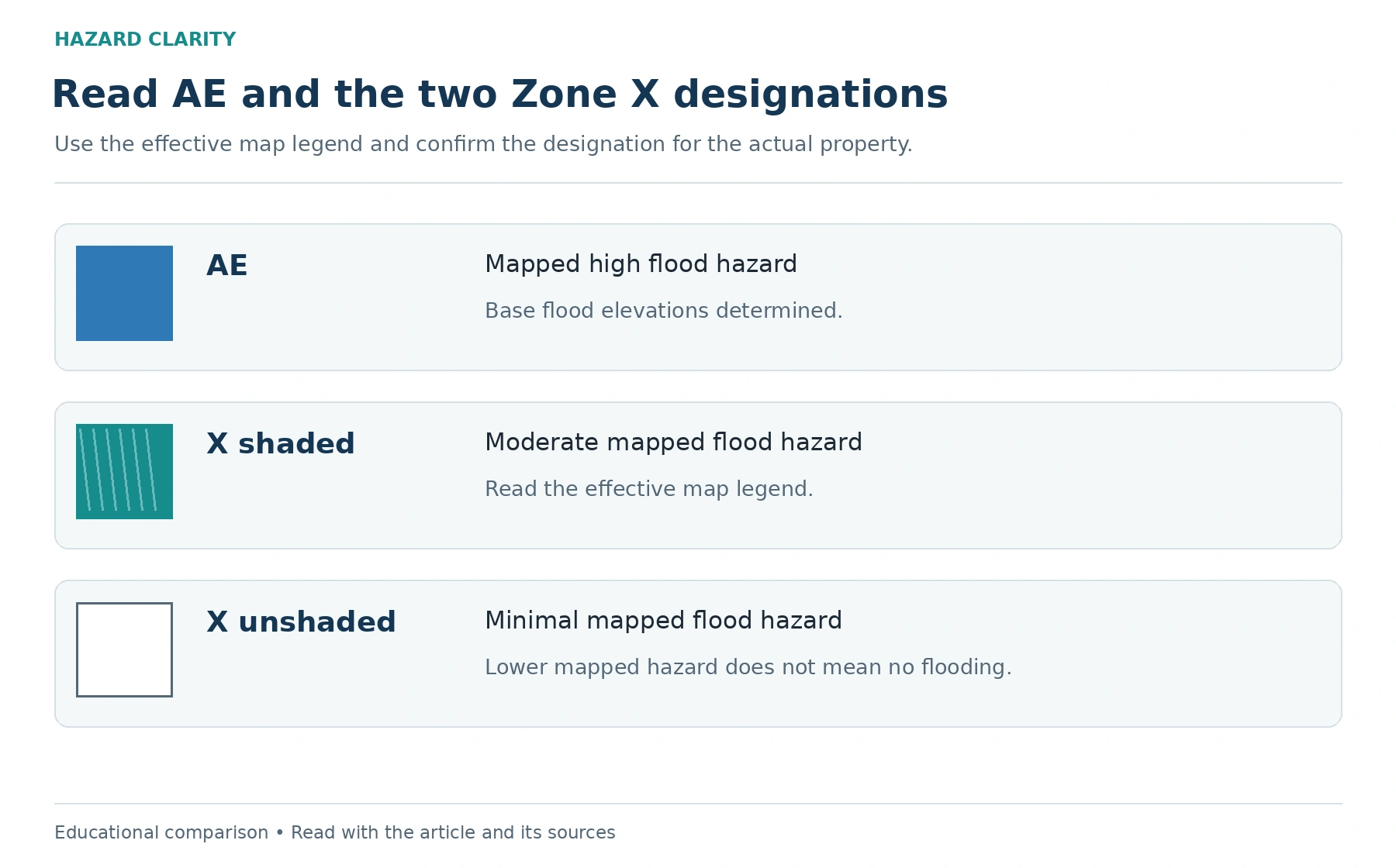
Flood Zone X and Flood Zone AE are FEMA map designations that help describe mapped flood hazards. AE is within the mapped high-risk area associated with the base flood, while Zone X identifies areas outside that Special Flood Hazard Area. Zone X can be shaded or unshaded, and that distinction matters when reading the map.
Neither label is a complete verdict on a home. An AE designation does not tell you exactly what a policy will cost or whether the property fits your plans. An X designation does not guarantee that flooding, drainage problems, or other water issues cannot occur. The useful next step is to understand the map, confirm how it relates to the building, and ask the right professionals about the remaining questions.
If you have not located the property yet, begin with HC’s guide to checking a FEMA flood zone. Then use this comparison to make sense of the information you find.
What Zone AE describes
Zone AE identifies an area with a mapped one-percent annual-chance flood hazard where base flood elevations have been determined. The base flood elevation is a reference elevation associated with that mapped flood. It should not be confused with the depth of water inside a particular home.
The designation directs attention to a meaningful floodplain question. It does not replace a survey, the lender’s flood determination, local permitting advice, or an insurance quote. You need to know how the mapped area relates to the actual structure and which records apply to the property.
If you see an elevation number, ask what it measures and which datum it uses. Comparing numbers from different references can create confusion. A qualified professional can explain the relationship between the flood information and the relevant building measurements.
What Zone X describes
Zone X is commonly discussed as though it means one thing, but maps distinguish shaded and unshaded areas. Shaded X generally identifies moderate flood hazards outside the one-percent annual-chance floodplain, including the area associated with the 0.2-percent annual-chance flood and certain other mapped conditions. Unshaded X generally identifies minimal mapped flood hazard outside that area.
Check the legend on the effective map rather than relying on a simplified label from a listing or search result. The map’s shading and definitions tell you more than the letter alone. If a screen makes the distinction hard to see, save the official map information and ask for help interpreting it.
Minimal mapped hazard is still a map classification. It does not establish that all rainfall, runoff, sewer, or groundwater questions have been answered for the property.
The annual chance is not a calendar promise
The phrase “100-year flood” can sound like a schedule. It is better understood as shorthand for a flood with a one-percent chance of being equaled or exceeded in any given year under the analysis. A flood does not reset a clock that guarantees a long period without another event.
For a homebuyer, the practical lesson is to avoid treating a recent event as proof that the question is finished. Review the map and property records, ask about documented history, and consider how you would manage ownership if a relevant event occurred.
You do not need to turn the probability into a personal prediction. The map helps identify a condition worth understanding. Your research should then focus on the actual building, available protection, and financial questions you need answered.
Locate the building rather than only the parcel
A parcel may include more than one mapped zone. A boundary may pass near the house, cross part of the lot, or sit close enough that an approximate address pin is difficult to interpret. The building’s location matters to the question being asked.
Confirm that you are reviewing the correct address and map panel. Look for the structure rather than assuming the map pin represents it precisely. If the result is close to a boundary, do not make a regulatory determination from a casual screenshot.
The lender, local floodplain administrator, and qualified surveying professionals may have different responsibilities in resolving the issue. Ask which document each needs. A clearer location review is more useful than confidently assigning the wrong designation.
Effective and preliminary maps have different roles
Communities can have map updates in progress. A preliminary map may show information that differs from the currently effective map. Those differences deserve attention, but the two should not be presented as interchangeable records.
Ask the local floodplain administrator which map is effective, whether an update is underway, and where to find applicable notices. Save the date of the information you reviewed. If an insurance or permitting question depends on a map update, request specific guidance from the person responsible for that decision.
A useful property file can include both the effective record and relevant future changes, clearly labeled. That gives you context without implying that a proposed update already controls every current decision.
Ask about amendments and supporting documents
An address may have a relevant Letter of Map Amendment or other official map-change document. If the seller mentions one, request the actual record rather than relying on a statement that the property was “taken out of the flood zone.”
Have the document reviewed for the correct property, structure, and scope. A letter can address a specific determination without eliminating every possibility of flooding. Its existence also does not let a general article decide the lender’s requirement or the insurer’s response.
If an elevation certificate is available, ask who prepared it and which questions it can answer. Keep it with the map information. Documents are most useful when they are read together by people who understand their purpose.
Insurance requirements and insurance decisions differ
Certain loans secured by buildings in Special Flood Hazard Areas are subject to federal flood-insurance requirements. A lender can explain how those requirements apply to the transaction and whether additional conditions exist. Do not assume a simplified online label is the final determination used for closing.
A buyer outside an area triggering a mandatory requirement still has a coverage decision to make. HC’s explanation of flood insurance outside high-risk zones can help organize that conversation.
Ask for written coverage options and the applicable effective date. Discuss limits, deductibles, building and contents protection, exclusions, and any waiting period. A zone designation alone is not a quote and should not be used to promise a premium or available policy.
Homeowners insurance is a separate review
A standard homeowners policy generally does not cover flood damage in the same way as a flood policy. Other water-related scenarios may involve separate terms or endorsements. That is why a map discussion should lead to specific policy questions rather than a broad assumption that “the house is insured.”
Read HC’s article on whether homeowners insurance covers flood damage for the basic distinction. Then have a licensed insurance professional explain the actual proposal for your property.
Ask how the policy treats the spaces you plan to use. A finished basement, stored belongings, mechanical equipment, and detached structures may raise different questions. The answer needs to come from the relevant policy documents, not from the zone letter.
A hypothetical comparison between two listings
Imagine two homes that meet your budget and location needs. The first is mapped AE and has available elevation documentation. The second is mapped unshaded X but has an unresolved history of yard drainage problems. The labels point to different research tasks, not an automatic winner.
For the first home, you might prioritize the building’s relationship to the map, the lender’s requirement, and written insurance options. For the second, you might prioritize drainage records and a professional evaluation of the reported condition, while still considering flood coverage.
Use the same framework for both: source, finding, question, responsible professional, and next step. This helps you compare documented information without making one label stand in for the entire property.
Bring useful questions to the showing and inspection
Ask for available flood-related disclosures, prior water-event information, repair records, and relevant map documents. Do not assume a seller’s short answer describes every source of water or every part of the parcel. Request clarification when the history is unclear.
At the inspection, discuss observable moisture signs and site features within the service’s scope. A dry inspection day cannot establish every past or future condition. If the concern goes beyond a general inspection, ask what additional professional evaluation may be appropriate.
Your REALTOR can help coordinate the research within contract deadlines. Local officials handle regulatory interpretation within their role. Insurance professionals handle policy questions. Clear responsibilities make the process easier to manage.
Build a simple map review checklist
Save the correct address, effective map panel, legend, and review date. Record whether the zone is AE, shaded X, unshaded X, or something else. Note any unclear boundary, amendment, elevation document, or pending map update.
Next, separate the remaining tasks into property, lender, and insurance questions. Identify who will answer each and when you need the response. Keep written answers with the documents so a later conversation does not depend on memory.
If two sources disagree, ask what each represents. One may be regulatory mapping while another is modeled exposure. Neither should be silently substituted for the other. A useful comparison explains the difference and keeps unresolved questions visible.
Use the designation to ask better questions
AE and X provide important context, but they are starting points for a property review. The practical goal is to understand the relevant map, the building, available documents, and coverage questions before you make your decision.
Run the address through Hazard Clarity to organize the information, then verify meaningful flood questions with the appropriate sources and professionals. A clear process is more useful than either dismissing Zone X or treating Zone AE as a complete judgment about the home.
Sources and reference material
FEMA and NFIP — What are flood zones and maps • Reviewed October 2, 2026
FEMA — Flood Map Service Center • Reviewed October 2, 2026
FEMA — How to read a Flood Insurance Rate Map • Reviewed October 2, 2026
Sources support the article’s factual foundations; the research workflow, worksheets, and hypothetical examples are original editorial guidance. Confirm current requirements and policy terms for the actual property before relying on a transaction-specific conclusion.
FEMA map legend reference for Zone AE and base flood elevation
See this property’s own hazard picture.
Check an address